2372 feet ASL
This was the second day of bagging 3 planned state highpoints (NJ, CT, and MA) during a summer vacation 2013 trip to Providence, RI. A few day earlier on the way up to Providence, I bagged NJ with the family. Today, I was solo, leaving from Providence to hit up CT and MA and return back to Providence. There was heavy rain in the forecast and even severe a bit to the west and south of where I was headed. I was up early trying to edge out the rain at my destination. Only drizzle at the trailhead, although the actual trail was a lake from previous rains. I tried in vain to walk on the edge of the trail and stay dry, but soon I embraced the wet, there was no other choice
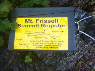
The highpoint of CT is interesting in that the highest point in the state is not the summit of a mountain, but rather on the side of the mountain, whose summit lies across the state line in MA. My route took me to the summit of Mount Frissell, but it was a few hundred yards down the mountain to the actual highpoint of CT. The log register at the summit of Mount Frissell explains the matter.
It was at the highpoint of CT that the rain caught up with me. From here on out, I would be wet and cold. But the highpoint (not summit) of CT was mine.
To complete the loop, there was another interesting marker, a tri-state point. This is a place where the borders of three states converge. In this case, CT, MA, and NY. CT must not have gotten the memo when the stone monument was being hewn because the CT designation was written in Sharpie, really CT.
I completed the loop and was back in my car heading to Mount Greylock, highest point in MA.
Mount Frissel slope (highpoint of Connecticut)
EveryTrail - Find hiking trails in California and beyond


No comments:
Post a Comment